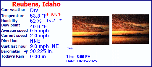
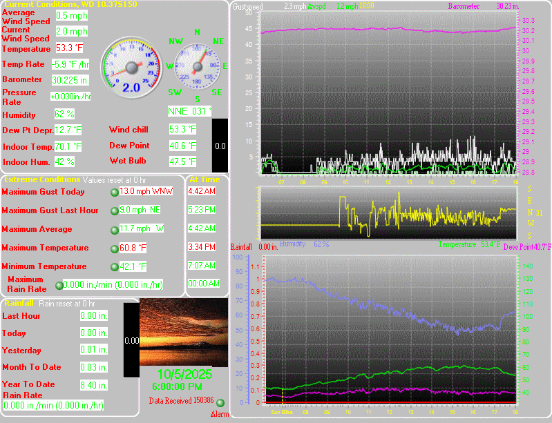
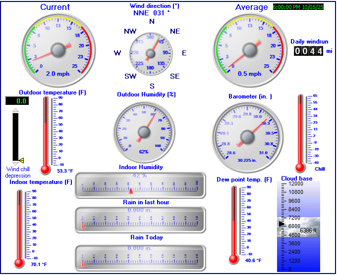
Camas Prairie Weather
LAST READING AT TIME: 6:30 AM DATE: April 19 2024, time of next update: 6:45 am
Current WeatherDry Current Temperature 30.0°F (-1.1°C), Apparent temp 26.3°F
Maximum Temperature (since midnight)36.4°F at: 12:00 AM Minimum Temperature (since midnight)28.5°F at: 5:28 AM
Average windspeed (ten minute)1.3 mph Wind Direction (ten minute)ESE (112°)
Windchill Temperature 30.0°F Maximum Gust (last hour)6.0 mph at: 5:50 AM
Maximum Gust (since midnight)7.0 mph at: 12:01 AM Maximum 1 minute average (since midnight)6.8 mph at: 12:10 AM
Rainfall (last hour)0.00 in. (0.0 mm) Rainfall (since midnight)0.00 in. (0.0 mm) ---
Rainfall This month 0.74 in. (18.8 mm) Rainfall To date this year 3.96 in. (100.6 mm)
Maximum rain per minute (last hour)0.00 in/min Maximum rain per hour (last 6 hours)0.00 in/hour
Yesterdays rainfall 0.00 in DewPoint 25.2°F (Wet Bulb :28.4°F )
Humidity 82 %, Humidex 24.6°F Barometer corrected to msl30.381 in. (1028.8 hPa)
Pressure change +0.02 in. (last hour) Trend (last hour)RISING SLOWLY
Pressure change (last 12 hours)+0.04 in Pressure change (last 6 hours)+0.02 in
Current Indoor Temp. 72.8°F
Current Indoor Hum. 32%

This page is updated from recent data collected by a DAVIS VANTAGE PRO weather station Use the Reload or Refresh facility on your browser to retrieve the latest data.


Click here for the last 24 hour graph
Click here for the last 48 hour graph
Click here for the last 72 hour graph
Click here for the month to date graph


Weather report/warning/Metars

Expires:202404192300;;006165
FPUS56 KOTX 190908
ZFPOTX

Zone Forecast Product for Eastern Washington and North Idaho
National Weather Service Spokane WA
207 AM PDT Fri Apr 19 2024


IDZ026-WAZ032-192300-
Lewiston Area-Lower Garfield and Asotin Counties-
Including the cities of Lewiston, Lapwai, Peck, Culdesac, 
Gifford, Clarkston, and Pomeroy
207 AM PDT Fri Apr 19 2024

.TODAY...Widespread frost in the morning. Sunny. Highs in the mid
50s to mid 60s. East wind 5 to 15 mph with gusts up to 25 mph. 
.TONIGHT...Clear. Lows in the 30s. Northeast wind 5 to 15 mph in
the evening, becoming light and variable. Gusts up to 25 mph. 
.SATURDAY...Sunny, warmer. Highs in the mid 60s to lower 70s.
East wind 5 to 15 mph with gusts up to 20 mph in the morning,
becoming light and variable. 
.SATURDAY NIGHT...Mostly cloudy with a 20 percent chance of rain
showers. Lows in the upper 30s to lower 40s. Southeast wind 5 to
15 mph with gusts up to 50 mph. 
.SUNDAY...Partly cloudy. Highs in the lower 50s to lower 60s.
Windy. West wind 15 to 25 mph with gusts up to 40 mph. 
.SUNDAY NIGHT THROUGH MONDAY NIGHT...Mostly clear. Lows in the
mid 30s to lower 40s. Highs in the upper 50s to mid 60s. 
.TUESDAY AND TUESDAY NIGHT...Mostly cloudy. Highs in the mid 60s
to lower 70s. Lows in the upper 30s to upper 40s. 
.WEDNESDAY AND WEDNESDAY NIGHT...Mostly cloudy with a 20 percent
chance of rain showers. Highs in the 60s. Lows in the 40s. 
.THURSDAY...Mostly cloudy with a 20 percent chance of rain
showers. Highs in the upper 50s to mid 60s. 

$$


Expires:202404192300;;006166
FPUS56 KOTX 190908
ZFPOTX

Zone Forecast Product for Eastern Washington and North Idaho
National Weather Service Spokane WA
207 AM PDT Fri Apr 19 2024


IDZ027-192300-
Lewis and Southern Nez Perce Counties-
Including the cities of Kamiah, Craigmont, Nezperce, 
and Winchester
207 AM PDT Fri Apr 19 2024

.TODAY...Widespread frost in the morning. Sunny. Highs in the
lower 50s to lower 60s. Gusts up to 20 mph in the afternoon. 
.TONIGHT...Clear. Lows in the 30s. Northeast wind 5 to 15 mph
with gusts up to 20 mph in the evening, becoming light and
variable. 
.SATURDAY...Sunny, warmer. Highs in the lower 60s to lower 70s.
Gusts up to 20 mph in the afternoon. 
.SATURDAY NIGHT...Mostly cloudy with a 50 percent chance of rain
showers. Lows in the upper 30s to lower 40s. Southeast wind 5 to
15 mph with gusts up to 40 mph. 
.SUNDAY...Mostly cloudy. Highs in the upper 40s to upper 50s.
Windy. West wind 15 to 25 mph with gusts up to 35 mph. 
.SUNDAY NIGHT THROUGH MONDAY NIGHT...Mostly clear. Lows in the
30s. Highs in the mid 50s to lower 60s. 
.TUESDAY AND TUESDAY NIGHT...Mostly cloudy. Highs in the mid 60s
to lower 70s. Lows in the mid 30s to mid 40s. 
.WEDNESDAY AND WEDNESDAY NIGHT...Mostly cloudy with a 20 percent
chance of rain showers. Highs in the 60s. Lows in the lower to
mid 40s. 
.THURSDAY...Mostly cloudy with a 40 percent chance of rain
showers. Highs in the mid 50s to lower 60s. 

$$


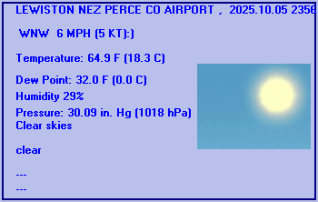
LEWISTON NEZ PERCE CO AIRPORT , ID, United States (KLWS) 46-22N 117-01W 438M
Apr 19, 2024 - 08:56 AM EDT / 2024.04.19 1256 UTC
Wind: Calm:0
Visibility: 10 mile(s):0
Sky conditions: clear
Temperature: 34.0 F (1.1 C)
Dew Point: 27.0 F (-2.8 C)
Relative Humidity: 75%
Pressure (altimeter): 30.24 in. Hg (1024 hPa)
ob: KLWS 191256Z AUTO 00000KT 10SM CLR 01/M03 A3024 RMK AO2 SLP247 T00111028
cycle: 13


The data is logged at two minute intervals, but there is data recorded every minute.

Use the RELOAD facility on your browser to retrieve the latest data.

Click here for a daily update of the averages/extremes to date for the month
Created by "Weather Display" software version 10.37S150 at this start time/date 10:32:37 PM 4/9/2024