| Camas Prairie Weather | |||
|---|---|---|---|
| LAST READING AT TIME: 4:15 AM DATE: July 29 2026, time of next update: 4:30 am | |||
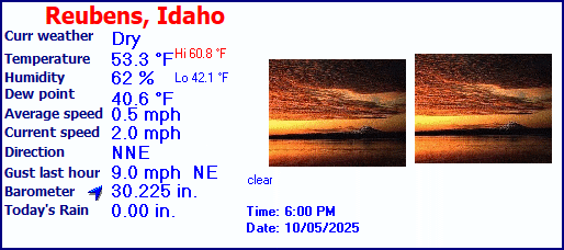
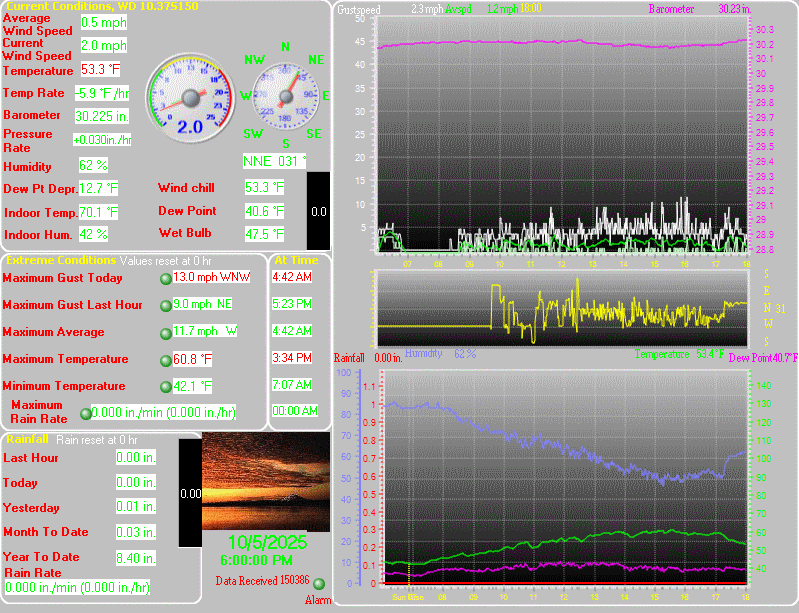
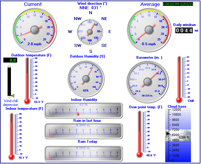
| Current Weather | Night time/Dry | Current Temperature | 56.1°F (13.4°C), Apparent temp 56.0°F |
| Maximum Temperature (since midnight) | 60.8°F at: 12:08 AM | Minimum Temperature (since midnight) | 54.8°F at: 1:53 AM |
| Average windspeed (ten minute) | 0.0 mph | Wind Direction (ten minute) | NW (315°) |
| Windchill Temperature | 56.1°F | Maximum Gust (last hour) | 2.0 mph at: 3:21 AM |
| Maximum Gust (since midnight) | 6.0 mph at: 3:09 AM | Maximum 1 minute average (since midnight) | 3.4 mph at: 3:03 AM |
| Rainfall (last hour) | 0.00 in. (0.0 mm) | Rainfall (since midnight) | 0.00 in. (0.0 mm) --- |
| Rainfall This month | 0.18 in. (4.6 mm) | Rainfall To date this year | 10.91 in. (277.1 mm) |
| Maximum rain per minute (last hour) | 0.00 in/min | Maximum rain per hour (last 6 hours) | 0.00 in/hour |
| Yesterdays rainfall | 0.00 in | DewPoint | 45.7°F (Wet Bulb :51.0°F ) |
| Humidity | 68 %, Humidex 56.6°F | Barometer corrected to msl | 29.969 in. (1014.9 hPa) |
| Pressure change | +0.02 in. (last hour) | Trend (last hour) | RISING SLOWLY |
| Pressure change (last 12 hours) | +0.06 in | Pressure change (last 6 hours) | +0.03 in |
| Current Indoor Temp. 70.7°F | |||
| Current Indoor Hum. 49% | |||
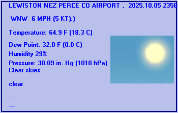
LEWISTON NEZ PERCE CO AIRPORT , ID, United States (KLWS) 46-22N 117-01W 438M
Jul 29, 2026 - 06:56 AM EDT / 2026.07.29 1056 UTC
Wind: from the S (170 degrees) at 3 MPH (3 KT):0
Visibility: 8 mile(s):0
Sky conditions: clear
Temperature: 64.9 F (18.3 C)
Dew Point: 43.0 F (6.1 C)
Relative Humidity: 44%
Pressure (altimeter): 29.95 in. Hg (1014 hPa)
ob: KLWS 291056Z AUTO 17003KT 8SM CLR 18/06 A2995 RMK AO2 SLP130 T01830061
cycle: 11
Use the RELOAD facility on your browser to retrieve the latest data.